
The two maps below show road access to a city hospital in 2007 and in 2010. Summarise the information by selecting and reporting the main features, and make comparisons where relevant.
TOEFL, IELTS, Personal Statement and CV Proofreading Services. › IELTS Writing › The two maps below show road access to a city hospital in 2007 and in 2010. Summarise the information by selecting and reporting the main features, and make comparisons where relevant.
-
The two maps below show road access to a city hospital in 2007 and in 2010. Summarise the information by selecting and reporting the main features, and make comparisons where relevant.
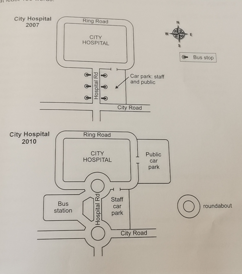
The two maps show the layout of the road access to a city hospital form 2007 to 2010.
Overall, it is evident that the car park was divided in public area and staff area, while some new infrastructures were bulit.
In 2007, the city hospital was surrounded by Ring Road, with the vertical Hospital Road below it. The City Road layed through the Hospital Road, which made them a cross. Six bus stops located in both left and right of Hospital Road. A car park for staff and public located in the north of City Road and east of Hospital Road.
In 2010, some changes happened and most located in the south of the map. The bus stops were removed and a big bus station replaced them. It was in the west of Hospital Road. The original car park became the staff car park, the public car park was converted to the east of Ring Road. What’s more, two roundabout were built in the Hospital Road. One was in the junction of Ring Road and Hospital Road, another was in the junction of City Road and Hospital Road. They all connected to the bust station.
Score: Ungraded
Issues:
- Extensive grammatical/punctuation errors.
- About 40% of the sentences are passive. Convert some of them into their active counterparts.
I will send you screenshots to illustrate specific problems/errors.
The two maps show the layout of the road access to a city hospital form 2007 to 2010.
Overall, it is clear that the car park was divided in public and staff areas and some new infrastructures were built beside the roads.
In 2007, Ring Road surrounded the city hospital, with the vertical Hospital Road below it. City Road was through the Hospital Road, which made them cross. Six bus stops located on both left and right of Hospital Road. A car park for staff and public located in the north of City Road and east of Hospital Road.
In 2010, some changes happened and most located in the south of the map. The six bus stops disappeared, and a big bus station replaced them. It was in the west of Hospital Road. The original car park became the staff car park while the public car park moved to the east of Ring Road. What’s more, two roundabouts were built on the Hospital Road. One was on the cross of Ring Road and Hospital Road and the other was on the cross of City Road and Hospital Road. They all connected to the bus station.
The two maps below show road access to a city hospital in 2007 and in 2010. Summarise the information by selecting and reporting the main features, and make comparisons where relevant.
Score: ungraded
Final Revision
The two maps show the layout [ word form error ]of the road access to a city hospital form [spelling error ]2007 to 2010.
Overall, it is clear that the car park was divided in [article error ]public and [article error ]staff area
s[punctuation error ]and some new infrastructures were built beside the roads.In 2007, Ring Road surrounded the city hospital, with the vertical Hospital Road below it[ unclear pronoun ]. [ article error ]City Road (was through)[ grammatical error/wrong word ] the Hospital Road(, which made them cross)[redundant ]. [ missing transition ]Six bus stops located on both [ article error ]left and [ article missing ]right of [article missing ]Hospital Road. A car park for [ article error ]staff and [ article error ]public located in the north of [ article error ]City Road and[ missing article ] east of [ missing article ]Hospital Road.
In 2010, some changes happened[ punctuation error ] and most[ unclear ] located [wrong word ]in the south of the map[ confusing ]. [ transition ]The six bus stops disappeared, and a big bus station replaced them. It [unclear pronoun ]was [ missing a verb ]in the west of [ article]Hospital Road. [ transition word missing]The original car park became the staff car park while the public car park [ voice error ]moved to the east of [ missing article ]Ring Road. What’s more, two roundabouts were built on the Hospital Road. One was on the cross of [missing article ]Ring Road and [ missing article ]Hospital Road [ punctuation error ]and the other was on the cross of [ missing article ]City Road and [missing article ]Hospital Road. They[unclear pronoun ] all connected to/with the bus station.
Watch video revision here: https://chinanudge.com/the-two-maps-below-show-road-access-to-a-city-hospital-in-2007-and-in-20100421/
The two maps show the layouts of the road access to a city hospital from 2007 to 2010.
Overall, it is clear that the car park was divided in the public and the staff area, and some new infrastructures were built beside the roads.
In 2007, Ring Road surrounded the city hospital, with the vertical Hospital Road below Ring Road. The City Road crossed the Hospital Road. In the same year, Six bus stops located on both the left and the right of the Hospital Road. A car park for the staff and the public located in the north of the City Road and the east of the Hospital Road.
In 2010, some changes happened, and most changes took place near the Hospital Road. At the same time, the six bus stops disappeared, and a big bus station replaced them. The bus station was built on the west of the Hospital Road. Meanwhile, the original car park became the staff car park while the public car park was moved to the east of the Ring Road. What’s more, two roundabouts were built on the Hospital Road. One was on the cross of the Ring Road, and the Hospital Road and the other was on the cross of the City Road and the Hospital Road. These two roads all connected with the bus station.
You must be logged in to reply to this topic.